 General Information
The US Army Corps of Engineers (USACE), Fort Worth District, is revising the Lake O’ the Pines Shoreline Management Plan (SMP). The purpose of the SMP is to establish policies and provide guidelines for managing the shoreline (lakeshore) and open water areas of Lake O’ the Pines, Texas, for the protection of desirable environmental characteristics and for the restoration of shorelines where degradation has occurred. The SMP establishes rules and guidelines for managing private uses of shoreline areas such as private boat docks and vegetation modification. The SMP must be compatible with the Lake O’ the Pines Master Plan, which was revised in 2018.
About Lake O’ the Pines
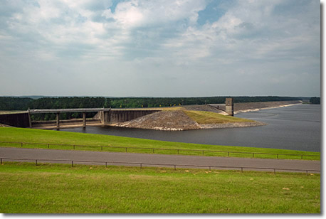
Lake O' the Pines was created by the construction of the Ferrells Bridge Dam on the Big Cypress Bayou, approximately 81 miles upstream from the Red River. Authorized by the Flood Control Act of 1946, the reservoir is part of the comprehensive plan for the control of floods within the Red River basin below Denison Dam, Oklahoma and Texas. Lake O’ the Pines is currently a multipurpose water resources project operated and maintained by USACE. Comprehensive management of Lake O’ the Pines and surrounding Federal lands requires balancing the needs of the surrounding population, visitors, and the ecological system. While the primary purposes of the project are flood risk management, and water conservation, the lake is also managed for public recreation and environmental stewardship, including fish and wildlife conservation. From 2007-2017, Lake O’ the Pines had over 600,000 visitors each year on average who enjoyed camping, fishing, boating, water skiing, hunting, sight-seeing, and much more.
What is a Shoreline Management Plan?
The Shoreline Management Plan addresses the rules and guidelines which govern private shoreline uses such as private boat docks, vegetation modification and similar private uses of government property. The SMP establishes shoreline allocations which specify where certain private uses are allowable. Shoreline allocations are dictated by Engineer Regulation ER 1130-2-406 and include: Limited Development Areas, Protected Shoreline Areas, Public Recreation Areas, and Prohibited Access Areas. Each of these allocations are defined in ER 1130-2-406, a copy of which is posted below. The Shoreline Management Plan complements the Lake O’ the Pines Master Plan.
Why Revise the Lake O’ the Pines Shoreline Management Plan?
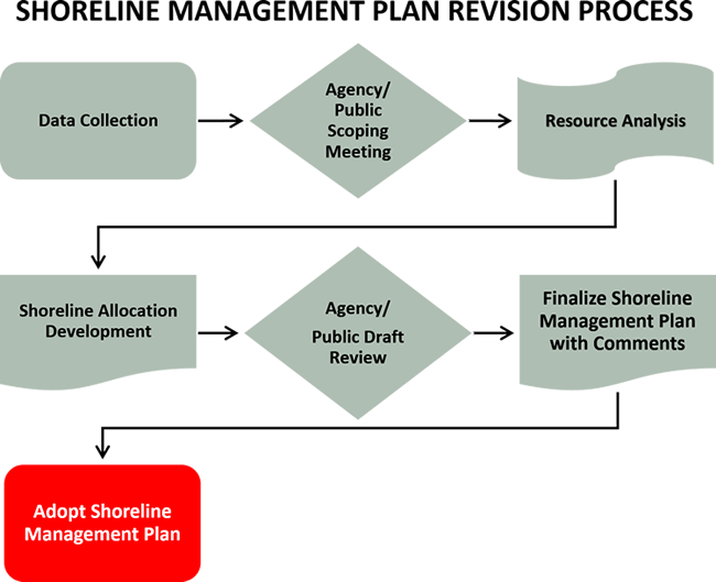
The current Shoreline Management Plan (SMP) for Lake O’ the Pines was prepared in 1978 and is posted below. The SMP is in need of revision to address changes in land use and policies since the current SMP was published. Key topics to be addressed in the revised SMP include revising shoreline allocations, and updating the plan to incorporate changes in public law and national policies related to shoreline management. The objective of the revision and related management actions will be to achieve a balance between permitted private uses and resource protection for general public use. Public participation is critical to the successful revision of the Shoreline Management Plan.
July 2020
October 2019
May 2019