 General Information
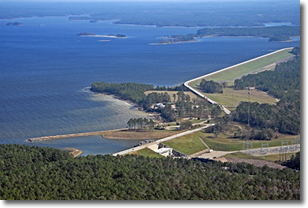
The U.S. Army Corps of Engineers, Fort Worth District, is revising the Sam Rayburn Reservoir Master Plan. The Master Plan guides the management of the government lands around the edge of the reservoir. The Master Plan affects future management of natural resources and recreational opportunities to ensure the sustainability of Sam Rayburn Reservoir.
About Sam Rayburn Reservoir
Sam Rayburn Dam and Reservoir was authorized and constructed for the primary purposes of flood control, generation of hydroelectric power, and conservation of water for municipal, industrial and agricultural uses. A major secondary use of project lands and waters is public water oriented recreation. The reservoir area is heavily utilized through visitation from the major industrial areas of Beaumont, Port Arthur, Houston, Lufkin, and other large population centers.
 |
Facts about Sam Rayburn Reservoir:
- Sam Rayburn Dam and Reservoir was dedicated on May 8, 1965
- At conservation (normal) pool elevation (164.4 feet NGVD) the reservoir covers 114,500 acres
- At the flood control pool elevation (173.0 feet NGVD) the reservoir covers 142,700 acres
- The shoreline at top of conservation pool is over 750 miles long, 560 miles of which are managed by USACE and the remainder being U.S. Forest Service
- 22,500 acres of land above conservation pool
- 27,723 acres of flowage easement
- Sam Rayburn is the largest reservoir completely within the borders of Texas
- The reservoir ranks routinely in the Top 10 of bass fishing lakes in the nation
|
What is a Master Plan?
The Master Plan is the strategic land use management document that guides the comprehensive management and development of all project recreational, natural, and cultural resources throughout the life of the water resources project.
Why Revise the Sam Rayburn Reservoir Master Plan?
Much has changed since the prior master plan was prepared in 1970. Expansion of residential development, changing outdoor recreation trends, new regional priorities for natural resources management, and a changed natural landscape from past flood events, and maturing vegetation have all resulted in the need to prepare a new Master Plan to guide future management.

Final Documents
January 31 and February 2 2017 Public Meetings
April 28, 29 2015 Public Meeting