EXECUTIVE SUMMARY
The purpose of the San Antonio Channel Improvement Project (SACIP) General Re-evaluation Report (GRR) and Environmental Assessment (EA), Westside Creeks (WSC), Ecosystem Restoration, San Antonio, Texas, is to identify ecosystem restoration measures to restore the riverine ecosystem within the WSC that is severely degraded due to the construction and continuing maintenance of the authorized and constructed SACIP and identify recreation opportunities that are compatible with the ecosystem restoration objectives. The GRR and integrated EA describe the characteristics of the existing and future without project conditions, water related resource problems and opportunities, planning objectives and constraints, formulation, evaluation, and comparison of alternatives, and identifies a recommended plan.
The SACIP was authorized under the Flood Control Act of 1954, Section 203, as part of a comprehensive plan for Flood Risk Management (FRM) in the Guadalupe and San Antonio River Basins. The authorization was modified in the Water Resources Development Act (WRDA) of 1976, Section 103, and WRDA 2000, Section 335. The modifications added ecosystem restoration and recreation as authorized purposes. The SACIP, GRR and EA was initiated at the request of the San Antonio River Authority (SARA) to evaluate the addition of ecosystem restoration and recreation purposes to the WSC. The Feasibility Cost Sharing Agreement for the study was executed on February 25, 2012.
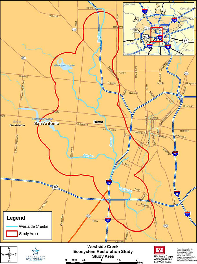
The WSC study area encompasses those portions of Martinez Creek, Alazán Creek, Apache Creek, and San Pedro Creek within the originally constructed SACIP footprint. These creeks, collectively known as the WSC, are located west of the San Antonio River on the west side of San Antonio (Figure ES1).
Changes in the hydraulic regime of the WSC over the last half-century are largely due to shifts in urbanization, the construction of the SACIP, and required operation and maintenance practices. Historic cross sections depict a more natural stream, consisting of a baseflow channel, a wider channel and a large floodplain. Straightening and channelization of the WSC yielded grass-lined trapezoidal channels, concrete banks, and an underground bypass tunnel (San Pedro). While the SACIP conveys flood flows more quickly out of the urban area, the channelization and required maintenance have resulted in unconsidered consequences for the riverine ecosystem along the 35 miles of the SACIP. Channelization has led to an increased bed slope and loss of sinuosity. The result is a system where the sediment transport is out of balance, few to none of the aquatic structures necessary to support and sustain the life cycle of aquatic organisms native to the system remain, and the required shading and allochthonous inputs from the riparian corridor have been removed, severely altering the function of the historic riverine habitat.
The Resource of National Significance for the study has been identified as migratory birds using the Central Flyway. The study area lies in a critical portion of that flyway, providing stop over habitat, feeding and breeding grounds during crucial times of the migrations.
Measures identified for the ecosystem restoration of the WSC to a more natural condition include riparian meadow (RM) in all areas of the creek, pilot channel (PC) for the length of the creek (with the exception of Apache where only the lower 0.8 miles of pilot channel would be restored), riparian woody vegetation (RWV) at densities of 30- and 70-trees per acre depending on hydraulic constraints, slackwater (SW) areas for the length of the restored pilot channel, and wetlands (WL). Table ES1 lists the seven alternatives in the final array along with specific creeks and associated management measures that are included for each alternative.
Table ES1 Final array of alternatives for Westside Creeks study.
| |
San Pedro |
Apache |
Alazan |
Martinez |
| Alt. 1 |
No Action |
No Action |
No Action |
No Action |
| Alt. 2 |
RM, PC, SW, RWV |
No Action |
No Action |
No Action |
| Alt. 3 |
RM, PC, SW, RWV |
RM, PC, SW, RWV |
No Action |
No Action |
| Alt. 4 |
RM, PC, SW, RWV |
RM, PC, SW, RWV |
RM |
No Action |
| Alt. 5 |
RM, PC, SW, RWV |
RM, PC, SW, RWV |
RM |
RM |
| Alt. 6 |
RM, PC, SW, RWV |
RM, PC, SW, RWV |
RM, PC, SW, RWV |
RM |
| Alt. 7 |
RM, PC, SW, RWV |
RM, PC, SW, RWV |
RM, PC, SW, RWV |
RM, PC, SW, RWV,WL |
| RM = Riparian Meadow; PC=Pilot Channel; RWV=Riparian Woody Vegetation at 30 & 70 stems per acre; SW= Slackwater; WL=Wetland. |
The recommended plan is the combined National Ecosystem Restoration (NER)/National Economic Development (NED) plan. The NER plan, Alternative 6, would restore 67% of the lower trophic organism carrying capacity possible for the WSC riverine system and provide 114% improvement in habitat quality over the no action alternative for 11 miles along the WSC. At maturity (75 years), the NER plan would provide 222 acres of mixed riparian meadow and riparian woody vegetation. The 6.5 mile pilot channel network would incorporate 146 pool-riffle-run sections and 143 off-channel slackwater areas in the existing SACIP right of way contributing to the restoration of aquatic habitat. The implementation of the NER plan would provide a total migratory bird diversity benefit of 101 average annual avian community units, which represents 82% of the diversity benefits available in the system, at a first cost (October 2012 prices) of approximately $39.4 million. The National Economic Development (NED) plan for recreation would provide 44,600 linear feet of concrete walk, jog, and bike trails. In addition to trails, other components include shade structures (6), interpretive/directional signage (50), benches (15), water fountains (15), picnic tables with pads (23), and trash receptacles (23). The first cost for recreational facilities is approximately $5.1 million with an average annual cost of approximately $272 thousand. With visitor days per year estimated at 481 thousand, the annua benefit is $3.9 million. The resulting net annual benefits are $3.6 million, and the benefit to cost ratio is 14.25. Monitoring and adaptive management is estimated at $800,000. First cost of the combined NER/NED plan is estimated at $45.3 million.
Restoration of the WSC riverine system will add to a larger habitat complex of the San Antonio River. With implementation of Alternative 6, this complex of preserved and restored riverine and upland habitat would amount to 1,492 acres and approximately 20 miles. Restoration of the WSC system and of the larger San Antonio River complex will provide benefits for diverse communities of aquatic organisms and wildlife.
Taken as a whole, restoration of the WSC system represents a potential for a significant contribution of riverine habitat benefits in a region where such habitats are scarce and declining. In addition to helping to reverse the national trend of declining riverine habitat, restoration of the WSC in conjunction with the on-going restoration along the San Antonio River would provide much needed riverine habitat benefits for migratory birds utilizing the Central Flyway during their Spring and Fall migrations. The recommended plan would effectively provide approximately 20 miles of connected, restored riverine system along a critical stop-over corridor for the birds utilizing the Central Flyway.
The San Antonio Channel Improvement Project, Westside Creeks Ecosystem Restoration Recommended plan:
- fulfills the U.S. Army Corps of Engineers (USACE) restoration mission,
- is in accordance with the USACE Civil Works Strategic Plan,
- is in accordance with the USACE Environmental Operating Principles,
- is in compliance with USACE restoration and recreation policies,
- is sustainable though the application of geomorphologic principles for sediment transport, hydraulic modeling, native vegetation species survivability, and synergistic effects,
- restores biological and environmental resources that were present prior to the construction of the SACIP,
- restores limiting habitat for neotropical migratory bird species,
- complements other Federal, state, and local restoration programs and projects,
- demonstrates ecosystem restoration and recreation co-exists effectively with the existing SACIP purpose of flood risk management,
- provides connection to adjacent restored and preserved habitats within the San Antonio River watershed,
- restores the creeks to a more natural structure and function resulting in the greatest practicable sinuosity, slope gradient, velocity, and sediment transport while maintaining the current effectiveness of the flood risk management function of the SACIP, and
- is supported by U.S. Fish and Wildlife Service, and Texas Parks and Wildlife Department, as well as having widespread local support.
The San Antonio River Authority (SARA), on behalf of the City of San Antonio and Bexar County, is identified as the non-Federal sponsor. SARA, City of San Antonio, and Bexar County support the recommended plan and, should the plan be approved, intend to participate in its implementation.
The draft GRR and EA will be available for public review July 31 – August 30, 2013. Two public meetings were held in the study area the week of June 24 – 28, 2013. The report is available in PDF on the Fort Worth District website, http://www.swf.usace.army.mil, and hard copies are available at the SARA office located at 100 E. Guenther St., San Antonio, Texas.
Comments or questions regarding the SACIP GRR and EA or the recommended plan should be addressed to Mr. Danny Allen, Environmental Planner, CESWF-PER-EC, U.S. Army Corps of Engineers, Fort Worth District, P.O. Box 17300, Fort Worth, Texas, 76102-0300, or call 817-886-1821, or use electronic mail at Daniel.Allen@usace.army.mil.
Documents and Appendices: