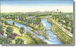
Project Overview
The Fort Worth District's Dallas Floodway Project is located in Dallas, Texas. It is a complex project in cooperation or partnership with multiple units of local, state and federal government. It addresses a number of regional concerns, although flood protection for the citizens of Dallas remains the cornerstone of this multi-faceted effort.
The U.S. Army Corps of Engineers has oversight responsibility for all activities within the federally authorized Dallas Floodway System. The Corps' Fort Worth District is a lead actor in some of the projects, such as the existing Dallas Floodway Project, which was strengthened and improved by USACE in the 1950s to reduce the risk of flooding from a flood event having a 1 in 800 chance of occurring in any given year. In other projects within the confines of the Dallas Floodway System listed below, the Corps plays a smaller supporting role or perhaps only an oversight function.
The Dallas Floodway Project is located along the Trinity River upstream from the abandoned Atchison, Topeka and Santa Fe (AT&SF) trestle to the confluence of the West and Elm Forks, then upstream along the West Fork for approximately 2.2 miles, and upstream about 4 miles along the Elm Fork.
The Dallas Floodway Project, in addition to the adjacent Dallas Floodway Extension Project, focus on three of five inter-related components within the Dallas Floodway System: flood protection, ecosystem restoration and recreation in partnership with the local sponsor, the City of Dallas.
The Corps of Engineers also has some role, but not a lead role, in two other major components: transportation and community/economic development.
Public safety is the No. 1 priority in the U.S. Army Corps of Engineers Levee Safety Program. The Dallas Floodway Project, now in the planning phase, is one of two Fort Worth District projects along the Trinity River designed to reduce flood risk for the citizens of Dallas. The other project, the Dallas Floodway Extension Project, is already in the construction phase. Both the Corps and the City of Dallas share the responsibility of public safety and both are committed to ensuring the integrity of the system. Each project has its own web section accessible from this Fort Worth District home page. The U.S. Army Corps of Engineers also provides public access to a National Levee Database providing more information on Dallas levees.
Modifications to the existing Dallas Floodway Project were authorized in the Water Resources Development Act (WRDA) of 2007, Public Law 110-114, Section 5141, at a total project cost of $459 million, with an estimated Federal share of $298 million and an estimated non-Federal share of $161 million. In light of multiple ongoing activities within the Floodway, a comprehensive assessment of all these actions was deemed appropriate, and was included in the scope of the current feasibility study.
Key Dallas Floodway Project Events
- Periodic Inspection. On Dec. 3-5, 2007, the USACE Fort Worth District conducted a Periodic Inspection of the Dallas Floodway. This was the ninth Periodic Inspection of the East Levee and West Levee, and was the first Periodic Inspection of the Rochester Park Levee and Central Waste Water Treatment Plant (CWWTP) Levee. (Congress in 1996 directed that the Rochester Park and CWWTP levee systems be added to the federally authorized Dallas Floodway System.) The result of the Periodic Inspection was released by the Fort Worth District to the City of Dallas on March 31, 2009. It rated the Dallas Floodway "unacceptable." This means there are deficiencies that would prevent the Floodway from performing as intended at the federally authorized level of 800-year flood protection and that remediation may be required.
- Feasibility Study and Environmental Impact Statement (EIS). An EIS is now being drafted. It is being integrated with a Feasibility Study for this project. The document is being developed by the Corps of Engineers Fort Worth District and the City of Dallas. The Feasibility Study/EIS will evaluate the technical soundness and potential comprehensive environmental consequences resulting from the implementation of proposed levee remediation, flood risk management, ecosystem restoration, recreation enhancement, and other proposed projects in and around the Dallas Floodway. A separate project website has been set up for the EIS and Environmental Assessments where additional documents are posted. This site will update progress in preparing the EIS. Section 5141 provides the flexibility to undertake a comprehensive, systemwide analysis to evaluate alternatives, including the Balanced Vision Plan, the Interior Drainage Plan, and other proposed non-federal modifications. The Federal Highway Administration is a cooperating agency in the study.
Major Dallas Floodway Project-Related Components
- Levee Remediation. Through Section 5141 the Corps of Engineers can participate in investigations and analyses regarding remediation of the Dallas Floodway System. This includes examination of changed conditions, and possible engineering or construction deficiencies that increase risk to public safety from a catastrophic flood event. Major urban development and land-use changes in the area, since the levee system was last modified in the late 1950s by the Fort Worth District, U.S. Army Corps of Engineers, has increased flood flows within the Floodway, thereby reducing the federally authorized level of protection below the current 800-year-level Standard Project Flood. In addition to potential levee raises, levee structural integrity concerns were identified in the Periodic Inspection Report that may require additional levee improvements and/or reconstruction.
Balanced Vision Plan. This City of Dallas plan for the Trinity River Corridor includes ecosystem restoration and recreation actions that will be evaluated in the EIS. These include creating meanders within the Trinity River, restoring, protecting and expanding the riparian corridor, improving aquatic habitat, creating riffle-pool complexes, and constructing wetlands. Recreation measures that will be evaluated include the West, Natural, and Urban lakes, terraced playing fields, multipurpose trails, whitewater facilities, pedestrian bridges, utilities, parking facilities, amphitheaters, promenade, concession pads, boat/canoe access points, and passive recreation features, such as interpretive guidance, media, and picnic areas.
- Interior Drainage Plan. This contains improvements proposed by the City of Dallas to aid drainage on the land side of the levee at existing and new pumping stations including Able, Baker, Charlie, Delta, Hampton, Trinity Portland, and Pavaho. These are designed to restore sump capacity to provide protection against the 100-year flood event and provide gravity and pressure storm sewers. The Pavaho Pump Station is already under construction.
- Local Features. These consist of features not included in the Balanced Vision Plan, Interior Drainage Plan nor authorized by Section 5141. These local features may be implemented by non-federal entities subject to a determination that the proposed alterations or modifications would meet USACE engineering and safety standards, and would not have significant adverse effects on the functioning of the protective facilities for the Dallas Floodway Levee System. These elements include:
- Section 408 levee modification at the 100-year level. In 2009 the Federal Emergency Management Agency (FEMA) de-accredited the Dallas Floodway. As a result, the City of Dallas began preparing a plan of levee modifications so that it could certify the levees as meeting a 100-year standard required for insurance purposes. FEMA is revising the Dallas 100-year floodplain map under its National Flood Insurance Progam. The City has submitted a Section 408 permit application to the Corps for these levee modifications. Construction is expected to start in 2012. If FEMA accepts the City's certification package, it could re-accredit the Dallas Floodway. FEMA's Flood Insurance Rate Map would then continue to show the levees provide protection from a flood likely to have a one-in-100 chance of happening in any given year.
- The Trinity Parkway is a proposed 9-mile toll road that would extend from the State Highway 183/IH-35E juncture to U.S. 175/Spur 310. Several route alternatives are currently being reviewed through the Federal Highway Administration National Environmental Policy Act process (a separate and independent EIS). Two of the routes being evaluated would be partially constructed within the existing Dallas Floodway.
- Trinity River Standing Wave includes the construction of an in-stream standing wave for recreational use, and covers approximately nine acres. It includes a canoe launch, small trails, a parking area, and ingress/egress points (launch and take-out) supported by retaining walls.
- Santa Fe Trestle Trail will be a hike and bike trail that provides access to Moore Park, located off East 8th Street south of downtown Dallas, and would be approximately 10.4 acres. It would cross the Trinity River via the AT&SF trestle, continue to a parking lot to be constructed south of the planned Trinity Parkway, and end as an access road at the north Trinity River levee near downtown Dallas. Construction of this city project will be complete is in early 2012.
- Pavaho Wetlands. The City of Dallas has proposed construction of 70 acres of storm water wetlands adjacent to the Pavaho Pumping Plant outfall.
- Margaret McDermott (IH-30) Bridge and IH-35E Bridge (Horseshoe Project) would include a signature bridge component over the Trinity River. The IH-30 Texas Department of Transportation bridge would carry 11 main lanes and one reversible HOV lane. Design work is being initiated for the IH-35E bridge. (The first signature bridge, the Margaret Hunt Hill Bridge, is due to open in March 2012.)
- Sylvan Avenue Bridge would replace the two-lane Sylvan Avenue approaches and low water crossing over the Trinity River with a single six-lane bridge structure that would span the Dallas Floodway. The proposed city project would accommodate a bike route across the bridge and relocate the existing boat ramp at Crow Lake Park.
Collapse All Expand All
Description. Interested parties are hereby notified that the U.S. Army Corps of Engineers (USACE), Fort Worth District, is currently seeking comments on an Environmental Assessment (EA) and draft Finding of No Significant Impact (FONSI) for the potential environmental consequences resulting from approving, pursuant to 33 U.S.C. 408 (Section 408), proposed modifications to the Dallas Floodway System in the City of Dallas, Dallas County, Texas. The City of Dallas, Texas is the proponent for this EA.
Statutory Authority. This notice is being issued to all interested parties in accordance with the National Environmental Policy Act of 1969 (NEPA), as amended, the Council on Environmental Quality Code of Federal Regulations (CFR) (40 CFR parts 1500-1508), and USACE Engineering Regulation 200-2-2. Under the terms of Section 408, any proposed modification to an existing USACE project, whether Federally or locally maintained, that goes beyond those modifications required for normal operations and maintenance requires a determination by the USACE that the proposed alteration, permanent occupation, or use of a federal project would not be injurious to the public interest and would not impair the usefulness of the existing project.
| The Environmental Assessment (EA) is also available for review at the following locations: |
Dallas Central Public Library
Government Information Center, 6th Floor
1515 Young Street
Dallas, Texas 75201
(214) 670-1482 |
Dallas West Branch Library
2332 Singleton Boulevard
Dallas, Texas 75212
(214) 670-6445 |
|
Mr. Jim Frisinger
CESWF-PM-ECSO
U.S. Army Corps of Engineers
Fort Worth District
P.O. Box 17300
819 Taylor Street
Fort Worth, Texas 76102-300
|